ArcGIS Server Banner

Creating feature classes

Creating feature classes

Release 9.3 E-mail This TopicPrintable VersionGive Us feedback

About creating feature classes

Note: This topic was updated for 9.3.1.

There are four primary ways to create a new feature class in your geodatabase:

You create empty feature classes in ArcCatalog. A new feature class can be created as part of a feature dataset or as a stand-alone feature class in a geodatabase. They can also be contained within the following structures: shapefile, coverage, CAD, SDC, and VPF.

When creating a feature class, you choose whether to create one that stores polygons, lines, points, annotation, multipoint, multipatch or dimension features. Refer to Defining feature class properties for information about the various properties that need to be set during the creation of a new feature class.

All feature classes in a feature dataset must use the same spatial reference, which is defined when the feature dataset is created. The exceptions to the rule are m domains; feature classes in the same feature dataset can have different m domains. When creating a stand-alone feature class, you must define its spatial reference.

How to create feature classes

Creating a feature class in a feature dataset

  1. In the ArcCatalog tree, right-click the feature dataset in which you want to create a new feature class.
  2. Point to New.
  3. Click Feature Class.
  4. Type a name for the feature class. To create an alias for this feature class, type the alias.
  5. Select from the drop-down list the type of features that will be stored in this feature class.
  6. If your data will require m- or z-values, check the appropriate check boxes.
  7. Click Next.
  8. If any feature class in the feature dataset will have measures, enter the M tolerance, or accept the default.
  9. By default, the Accept default resolution and domain extent check box is checked. If you want to manually adjust the resolution and domain extent values of your new dataset, uncheck this box. If you are creating data in a pre-9.2 geodatabase or chose Unknown for the horizontal coordinate system, you should uncheck this box and confirm that the default values are appropriate.
  10. If you have unchecked the Accept default resolution and domain extent check box, there is an additional panel in the wizard that allows you to change the M resolution as well as the minimum and maximum m-values.
  11. If your geodatabase is not a file or ArcSDE Enterprise geodatabase, skip to step 13. If you want to create the table using a custom storage keyword, click Use configuration keyword, then specify the keyword you want to use.

    NOTE: ArcInfo and ArcEditor only

  12. Click Next.
  13. To add a field to the feature class, click the next blank row in the Field Name column, then type a name.
  14. Click in the Data Type column next to the new field's name, and click its data type.
  15. To create an alias for this field, click the field next to Alias, and type the alias for this field.
  16. To prevent nulls from being stored in this field, click the field next to Allow nulls, click the drop-down arrow, and click No.
  17. To associate a default value with this field, click the field next to Default value and type the value.
  18. To associate a domain with this field, click the field next to Domain, click the drop-down arrow to see a list of the domains that apply to this field type, and click the domain.
  19. To set other properties specific to the type of field, either click the property in the drop-down list or type the property.
  20. Repeat steps 13 through 19 until all the feature class fields have been defined.
  21. If you want to import field definitions from another feature class or table, click Import.
  22. Click Finish.

Tips

  • When creating a new feature class, you can use another feature class as a template. Click Import, navigate to the feature class that contains the field definitions you want to copy, then click OK. Now you can edit the field names and their data types.
  • All simple feature classes in the geodatabase require an ObjectID and geometry type fields. You won't be able to delete the default ObjectID and geometry fields in this wizard.
  • When adding a feature class to a feature dataset, the Spatial Reference button lets you review the feature dataset's spatial reference parameters; however, you can't change them. The exception to the rule is m domains; feature classes in the same feature dataset can have different m domains.
  • You must be the owner of a feature dataset to add feature classes to it.

Creating a stand-alone feature class

  1. In the ArcCatalog tree, right-click the database in which you want to create a new feature class.
  2. Point to New.
  3. Click Feature Class.
  4. Type a name for the feature class. To create an alias for this feature class, type the alias.
  5. Select the type of features from the drop-down list that will be stored in this feature class.
  6. If your data will require m- or z-values, check the appropriate check boxes.
  7. Click Next.
  8. Navigate to the spatial reference you want to use, or click Import and navigate to the feature class or feature dataset that uses the spatial reference you want to use as a template.
  9. Click Modify if you want to change any parameters in the coordinate system you've chosen. Edit the coordinate system's parameters and click OK.
  10. If your data requires a vertical coordinate system, you may import one from another feature class or feature dataset; otherwise, select None. Click Modify if you want to change any parameters in the coordinate system you've chosen. Edit the coordinate system's parameters and click OK.
  11. Enter an x,y tolerance or accept the default value. The default x,y tolerance is 1 mm on the Earth's surface at the point of projection.
  12. If any feature class in the feature dataset will have z-values, enter the z tolerance or accept the default.
  13. If any feature class in the feature dataset will have measures, enter the m tolerance or accept the default.
  14. If you've changed the x,y, z, and/or m tolerances and want to revert to the default values, click the Reset all tolerances button.
  15. By default, the Accept default resolution and domain extent check box is checked. If you want to manually adjust the domain and extent values of your new dataset, uncheck this box. If you are creating data in a pre-9.2 geodatabase or chose Unknown for the horizontal coordinate system, you should uncheck this box and confirm that the default values are appropriate.
  16. If you have unchecked the Accept default resolution and domain extent check box, there is an additional panel in the wizard that allows you to change the x,y, z, and m resolution as well as the minimum and maximum z- and m-values.
  17. If your geodatabase is not a file or ArcSDE Enterprise geodatabase, skip to step 19. If you want to create the table using a custom storage keyword, click Use configuration keyword and specify the keyword you want to use.

    NOTE: ArcInfo and ArcEditor only

  18. Click Next.
  19. To add a field to the feature class, click the next blank row in the Field Name column, then type a name.
  20. Click in the Data Type column next to the new field's name and click its data type.
  21. To create an alias for this field, click the field next to Alias and type the alias for this field.
  22. To prevent nulls from being stored in this field, click the field next to Allow nulls, click the drop-down arrow, and click No.
  23. To associate a default value with this field, click the field next to Default value and type the value.
  24. To associate a domain with this field, click the field next to Domain, click the drop-down arrow to see a list of the domains that apply to this field type, and click the domain.
  25. To set other properties specific to the type of field, either click the property in the drop-down list or type the property.
  26. Repeat steps 19 through 25 until all the feature class fields have been defined.
  27. Click Import if you want to import field definitions from another feature class or table.
  28. Click Finish.

Tips

  • Want your most frequently used coordinate systems to appear at the top of the list in the wizard so you don't have to navigate down through the tree? First, exit out of the wizard. Now in ArcCatalog, turn on the Coordinate Systems folder (Tools > Options dialog box General tab) if it is not already turned on. Inside the Coordinate Systems folder, drag and drop, or copy and paste, the coordinate systems you use most frequently into the top level of the folder. For example, copy a coordinate system from inside one of the subfolders and then right-click the Coordinate Systems folder and choose Paste. (If you drag and drop coordinate systems to the top level of the Coordinate Systems folder, they are automatically copied, not moved, by ArcCatalog, so they will still be accessible via their original subfolder too.) You can also create new subfolders or reorganize the existing subfolders. Now when you go into the New Feature Class wizard again, you'll see those coordinate systems that you moved to the top of the Coordinate Systems folder at the top of the list.
  • Click Import to populate the Spatial Reference Properties dialog box with information from another feature class. You can then customize the template's spatial reference.
  • To modify a predefined (or a template's) coordinate system or to define a custom coordinate system from scratch, click Custom on the Coordinate System dialog box.
  • Since the size of the spatial domain is dependent on the value of precision, when the precision is changed, the maximum z-value will change to fit within the size of the spatial extent. Similarly, when the maximum z-value is changed, the precision will change to fit the domain extent.

Creating a new feature class using geoprocessing tools

The Create Feature Class geoprocessing tool is located in the Data Management toolbox under Feature Class. Like the New Feature Class wizard in ArcCatalog, this will create an empty feature class.

Creating a new feature class by saving the contents of a map layer in ArcMap

If you are working with a dataset in ArcMap, you can export it to create a feature class or a shapefile.

  1. Right-click the dataset you would like to export to bring up the context-sensitive menu.
  2. Navigate to Data and choose Export Data.
  3. Exporting data from ArcMap

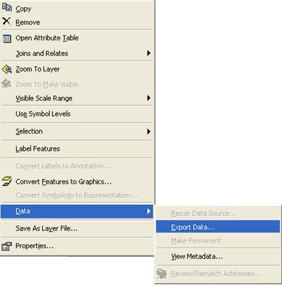
    This brings up the Export Data dialog box.

    Export data dialog

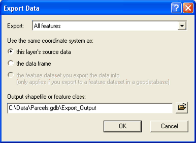
  4. From the drop-down list, choose whether you would like to export all features or just those in the view extent.
  5. Choose one of three radio button options for which coordinate system the exported dataset will inherit. These include the following:
  6. Specify the output data you would like to create.
  7. Do one of the following:

    Type the name of the output directly into the field. It will be saved into the current output location. Move the cursor over the browse button to get a tip showing you the current output location. (If the current location is a file geodatabase, it will have a .gdb extension; if it’s a personal geodatabase, it will have an .mdb extension; if it's an ArcSDE Personal or Workgroup geodatabase on a database server, it will have a .gds extension; if it’s a connection to a spatial database, it will have an .sde extension).

    Or, click the browse button. Use the browser to specify the location and name of the output data.

    If you save the output to a folder (e.g., a directory on disk), it will be saved as a shapefile. You can use spaces in the shapefile name. If you don't specify an .shp extension, ArcMap will automatically add it for you.

    If you save the output into a geodatabase (a file, personal, or ArcSDE geodatabase), it will be saved as a geodatabase feature class. You cannot use spaces in the name of a feature class.

    NOTE: If you type the name of the output directly into the field instead of using the browser, you can specify a full path name, but only if the path name is to a location currently accessible in the browser (or ArcCatalog) via an existing folder connection or database connection. For example, to specify a new feature class called states in an existing personal geodatabase called USA.mdb, you can type d:\data\usa.mdb\states. This will only work if the browser (or ArcCatalog) already contains a folder connection to either d:\ or d:\data.

Converting an external data source into a geodatabase feature class

To convert an external data source to a geodatabase feature class, you use the import tools either in ArcCatalog or ArcToolbox.

There are two ways you can import a feature:

When you import data that is in a format not used by the geodatabase, ArcGIS automatically converts it into data types used by the geodatabase.

Learn more about how data converts when importing.