Defining symbology for input feature sets
Defining symbology for input feature sets
|
| Release 9.3 |
   |
Note: This topic was updated for 9.3.1.
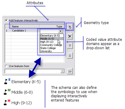
Many geoprocessing tasks use feature sets as input. When you create a feature set variable, you set a schema that defines the shape type (point, line, or polygon), the attributes you wish the user to supply, and the symbology used to display the features that the user digitizes, as illustrated below.
 Learn more about feature sets
The client application is responsible for displaying the features the user digitizes. This means that the symbology you define for the feature set must be symbology that the client can display.The topic Defining output symbology for geoprocessing tasks describes the symbology supported on all clients. Although the topic discusses output symbology, the same rules apply for feature set symbology. These rules are summarized below.
The following layer symbologies are supported by all clients:
Learn more about feature sets
The client application is responsible for displaying the features the user digitizes. This means that the symbology you define for the feature set must be symbology that the client can display.The topic Defining output symbology for geoprocessing tasks describes the symbology supported on all clients. Although the topic discusses output symbology, the same rules apply for feature set symbology. These rules are summarized below.
The following layer symbologies are supported by all clients:
- Features
- Categories
- Quantities
- Graduated colors
- Graduated symbols
The table below shows the ArcMap symbol types that all clients can use. If your client is ArcMap or ArcGIS Explorer, there are additional choices. Again, see the topic Defining output symbology for geoprocessing tasks for more details.
| Points |
Lines |
Polygons |
|---|
| Simple Marker Symbol |
Simple Line Symbol |
Simple Fill Symbol |
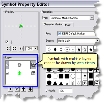
| Character Marker Symbol (see note below) |
|
Picture Fill Symbol |
| Picture Marker Symbol |
|
|
Character Marker Symbols can have multiple symbol layers, as illustrated below. Symbols with multiple layers cannot be drawn by web clients.
NOTE: When you apply a schema, the schema is read and stored with the model variable. If you subsequently change the schema—for example, change the symbology or add a coded value domain—you need to reapply the schema.
- In ModelBuilder, right-click the feature or record set variable and choose Properties.
- Click the Data Type tab.
- Choose the schema (dataset, layer file, or layer) again and click OK.
After changing the schema and saving the model, you must re-create the tool layer (if you are using ArcMap to publish your service), then restart the service.
Because the schema is stored with the feature or record set, you can delete the schema once it has been applied.
