
|
About compressing file geodatabase data |
|
| Release 9.3 |    |
 When you compress a geodatabase, all feature classes and tables within it compress. When you compress a feature dataset, all its feature classes compress.
The ability to compress and uncompress is also available through geoprocessing tools in the File Geodatabase toolset, located in the Data Management toolbox. For more information, see An overview of the File Geodatabase toolset.
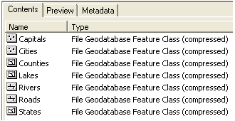
A compressed feature class or table looks the same as when it was uncompressed, but you can tell whether data is compressed by listing feature classes and tables in the ArcCatalog Contents tab. A compressed feature class or table has "(compressed)" in the Type column.
When you compress a geodatabase, all feature classes and tables within it compress. When you compress a feature dataset, all its feature classes compress.
The ability to compress and uncompress is also available through geoprocessing tools in the File Geodatabase toolset, located in the Data Management toolbox. For more information, see An overview of the File Geodatabase toolset.
A compressed feature class or table looks the same as when it was uncompressed, but you can tell whether data is compressed by listing feature classes and tables in the ArcCatalog Contents tab. A compressed feature class or table has "(compressed)" in the Type column.
 Another way you can tell is by opening the Feature Class or Table Properties dialog box. The General tab states whether the data is compressed.
Benefits of compression
Compressed file geodatabase data takes up less disk space than uncompressed data while still offering comparable display and query performance.
The amount of compression possible in feature classes and tables can range from a negligible amount to a ratio exceeding 4:1. The makeup of coordinates and the number of attribute fields and their contents determine the amount of compression possible.
The most important factor for feature classes is the average number of vertices per feature. Points and simple two-vertex lines compress more than lines or polygons with many vertices. A feature class of address points or roads with few vertices, for example, may compress by a ratio of 3:1, whereas a feature class of rivers or soil data with many vertices per feature may only compress by a ratio of 3:2. Features with many vertices already store efficiently when uncompressed, and as a result, there is less potential for compression. Attribute fields also play a role in determining the amount of compression: text, integer, and date fields compress better than floats and doubles.
The following examples compare uncompressed and compressed format file sizes. The feature class achieving the greatest amount of compression relative to its original size, Europe places, is a point feature class. The feature class with the least amount of compression, Mexico roads, is a line feature class with many vertices per feature.
Another way you can tell is by opening the Feature Class or Table Properties dialog box. The General tab states whether the data is compressed.
Benefits of compression
Compressed file geodatabase data takes up less disk space than uncompressed data while still offering comparable display and query performance.
The amount of compression possible in feature classes and tables can range from a negligible amount to a ratio exceeding 4:1. The makeup of coordinates and the number of attribute fields and their contents determine the amount of compression possible.
The most important factor for feature classes is the average number of vertices per feature. Points and simple two-vertex lines compress more than lines or polygons with many vertices. A feature class of address points or roads with few vertices, for example, may compress by a ratio of 3:1, whereas a feature class of rivers or soil data with many vertices per feature may only compress by a ratio of 3:2. Features with many vertices already store efficiently when uncompressed, and as a result, there is less potential for compression. Attribute fields also play a role in determining the amount of compression: text, integer, and date fields compress better than floats and doubles.
The following examples compare uncompressed and compressed format file sizes. The feature class achieving the greatest amount of compression relative to its original size, Europe places, is a point feature class. The feature class with the least amount of compression, Mexico roads, is a line feature class with many vertices per feature.
| Feature class | Uncompressed size | Compressed size | Compression ratio |
|---|---|---|---|
| Europe places (61,541 point features, 14 fields) | 6.2 MB | 1.3 MB | 4.8 |
| Germany streets (7,118,614 line features, 83 fields) | 2.3 GB | 511 MB | 4.5 |
| U.S. census blocks (8,205,055 point features, 11 fields) | 705 MB | 162 MB | 4.4 |
| California roads (2,092,079 line features, 29 fields) | 329 MB | 83 MB | 3.9 |
| Europe rails (383,531 line features, 12 fields) | 58 MB | 17 MB | 3.4 |
| Calgary addresses (285,285 point features, 8 fields | 21 MB | 7.4 MB | 2.8 |
| Calgary buildings (319,000 polygon features, 9 fields) | 48 MB | 20 MB | 2.4 |
| U.S. rivers and streams (2,844,231 line features, 9 fields) | 878 MB | 442 MB | 2.0 |
| U.S. counties (3,140 polygon features, 57 fields) | 1.6 MB | 1.0 MB | 1.6 |
| Europe water (232,375 polygon features, 10 fields) | 176 MB | 125 MB | 1.4 |
| U.S. traffic analysis zones (166,747 polygon features, 10 fields) | 68 MB | 46 MB | 1.4 |
| Mexico roads (5,847 line features, 7 fields) | 3.5 MB | 2.7 MB | 1.3 |
| Feature class | Uncompressed size | Compressed size |
|---|---|---|
| Calgary buildings, 0.0001-meter resolution | 48 MB | 20 MB |
| Calgary buildings, 1.0-meter resolution | 31 MB | 12 MB |
| File geodatabase data | Able to compress |
|---|---|
| Geodatabase | Yes. All vector feature classes and tables in the geodatabase compress. |
| Feature dataset | Yes. All vector feature classes in the feature dataset compress. |
| Feature class (stand-alone only) | Yes |
| Table | Yes |
| Raster dataset | No |
| Raster catalog | No |
| Terrain | No |
| Schematic | No |
| Cadastral fabric | No |
| Survey dataset | No |
| Relationship class | Topology | Geometric network | Network dataset | Terrain | |
|---|---|---|---|---|---|
| Able to compress feature classes in these | Yes | Yes | Yes | Yes | Yes |
| Able to create on compressed feature classes | Yes | No | No | Yes | Yes |
| Able to edit properties | Yes | No | Yes | Yes | Yes |