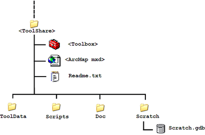
|
Guide to the geoprocessing service examples |
|
| Release 9.3 |    |
| Example | Description |
|---|---|
| Buffer points (step-by-step) | A simple model to buffer point features. |
| Buffer features | Expands the above service to buffer line and polygon features. |
| Watershed (step-by-step) | Creates a watershed polygon from input points. |
| Stream network | Produces a stream network for cartographic display. |
| More Stream network | Expands the above service by allowing the user to download existing stream networks. |
| Clip and ship | Extracts data based on area of interest polygons. Creates a file geodatabase of the extracted features, compresses the geodatabase into a .zip file, and optionally emails the .zip file to the user. |
| Data on demand | Much like the above example, but makes extensive use of scripting. |
| Selecting data | Shows a variety of ways to select data by attribute and location. |
| Drivetime polygons | Creates polygons based on drive–time around points. |
| Shortest route on a street network | Finds the shortest route on a street network. |
| Finding nearby features over a street network | Finds features closest to a given location based on shortest route on a street network. |