Geometric networks and network datasets in a geodatabase in DB2
Geometric networks and network datasets in a geodatabase in DB2
|
| Release 9.3 |
   |
Note:This topic was updated for 9.3.1.
Geometric networks are collections of line (edge) and point (junction) feature classes in a feature dataset that possess a connectivity relationship. Geometric networks are used to model infrastructure, such as electirc utility lines and sewer systems.
Network datasets are also collections of feature classes that possess a connectivity relationship, but network datasets are created using three types of sources—edge feature sources, such as street centerlines, junction feature sources, such as point feature classes containing railroad crossings, and turn feature sources. They are used to model transportation. To use network datasets, you must have the Network Analyst extension installed.
The tables that get created with a network depend on whether you create a geometric network or a network dataset and also whether or not there are turns present in the network.
Networks in ArcCatalog
In the Catalog tree, feature datasets that contain geometric networks and network datasets in a DB2 database management system (DBMS) look the same until you expand the dataset. Once the dataset is expanded, you will see either a geometric network or network dataset. For example, for a geometric network, you would see a layer similar to the following:
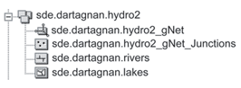 In this example, hydro2_gNet is the geometric network in the dataset.
For a network dataset, you would see something similar to the following:
In this example, hydro2_gNet is the geometric network in the dataset.
For a network dataset, you would see something similar to the following: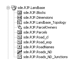 Roads_ND is the network dataset. Roads_ND_Junctions are the junctions for the Roads network dataset.
Top of page
Roads_ND is the network dataset. Roads_ND_Junctions are the junctions for the Roads network dataset.
Top of page
Networks in a DB2 DBMS
Networks are tracked in system tables and network tables. The following are the system tables used for a geometric network:
- GDB_GEOMNETWORKS
- GDB_NETWORKS
- GDB_NETWEIGHTS
- GDB_NETWEIGHTASOCS
- GDB_NETCLASSES
Network datasets are maintained in these system tables:
- GDB_EXTENSIONDATASETS
- GDB_NETWORKS
- GDB_NETWEIGHTS
- GDB_EDGECONNRULES
- GDB_JNCONNRULES
See System tables of a geodatabase in DB2 for descriptions of these tables.
In addition to these tables the network is a set of variably sized tables. The size of these tables depends on the size of the network—for example, number of junctions #J and number of edges #E.
There are 10 fixed tables per network, and they are identified by the following naming convention N_*_<table_descriptor>, where the '*' represents the ID of the network in the GDB_Networks table; for example, N_1_<table descriptor>, N_2_<table descriptor>. The actual number of tables varies depending on what type of network you create—geometric network or network dataset—and what elements the network contains. A maximum of 21 tables could get created for a network dataset with turns and weights.
All of these tables are versioned when the network itself is versioned.
The 10 tables that are always created are the N_<ID>_Desc, N_<ID>_E<#>, N_<ID>_ESTATUS, N_<ID>_ETOPO, N_<ID>_FLODIR, N_<ID>_JDESC, N_<ID>_JSTATUS, N_<ID>_JTOPO, N_<ID>_JTOPO2, and N_<ID>_PROPS tables. (See below for descriptions.)
NOTE: The N_<ID>* tables can be viewed in the DBMS but should not be altered using SQL/third-party applications; doing so can corrupt the network.
N_<ID>_<>Tables in the geodatabase that begin with N_ store information about networks.
N_<ID>_DESCThe N_<ID>_Desc table describes the elements of a network. This is a normalized table whose row count is equal to the number of junctions and the number of edges in a geometric network.
| Field name |
Field type |
Description |
|---|
| OID |
INTEGER |
The unique ID of an element in a geometric network
NOT NULL |
| USERCLASSID |
INTEGER |
The ID of the feature class to which the element belongs
NOT NULL |
| USERID |
INTEGER |
The object ID of the feature
NOT NULL |
| USERSUBID |
INTEGER |
The ID of an element in a feature; only applicable to complex edge features
NOT NULL |
| ELEMENTTYPE |
SMALLINT |
A code indicating the type of network element
1 = junction
2 = edge
NOT NULL |
| EID |
INTEGER |
The unique element ID of the network element; the element ID is only unique for the type of network element
NOT NULL |
N_<ID>_PROPSThe N_<ID>_PROPS table contains a summary description of a a network's properties, such as element counts and maximum EID values.
| Field name |
Field type |
Description |
|---|
| PROPERTYID |
INTEGER |
The unique ID of the network property |
| PROPERTYNAME |
VARCHAR(32) |
The name of the property |
| PROPERTYVALUE |
INTEGER |
The value of the property |
All of the remaining network tables contain the same field names and types. The table names and what they track are described below the table definition. Those tables that track turns would not be used in a geometric network dataset.
| Field name |
Field type |
Description |
|---|
| OID |
INTEGER |
The unique ID of the BLOB page in the table
NOT NULL |
| PAGENUMBER |
INTEGER |
The number of the BLOB page in the table
NOT NULL |
| PAGEBLOB |
BLOB |
The desciription for the element the table is describing, such as edge, and edge status |
N_<ID>_E<#>—Describe network edge weights; # = 2, 3, 4, or 5N_<ID>_EDESC—Describes the edges in a networkN_<ID>_ESTATUS—Describes the status of each edge including its deleted and disabled statesN_<ID>_ETOPO—Describes the network edge topology or connectivityN_<ID>_ETURN*—Indicates whether each edge participates in a turnN_<ID>_ETURN2*—Lists which turns pass through each edge in the networkN_<ID>_FLODIR—Describes the network flow directionN_<ID>_J<#>—Describe network junction weights; # = 0 or 1N_<ID>_JDESC—Describes the network junctionsN_<ID>_JSTATUS—Describes the status of each network junction including its deleted and disabled statesN_<ID>_JTOPO—Describes the connectivity of junction elements with edge elements.N_<ID>_JTOPO2—Describes the connectivity of junction elements with edge elements when there are multiple edges connected to a single junction.N_<ID>_JTURN*—Indicates whether each junction participates in a turnN_<ID>_JTURN2*—Lists which turns pass through each junction in the networkN_<ID>_T<#>*—Describes the weight values of each turn elementN_<ID>_TDEFN*—Defines each turn element by listing the edges and junctions that make up the turn.N_<ID>_TDEFN2*—Overflow table for the turn element definition; for example, if multiple edges make up a turn.N_<ID>_TDESC*—Describes the turns in a networkN_<ID>_TSTATUS*—Describes the status of each network turn, including its deleted and disabled states.
*Would not be present in a geometric network or network dataset without turns.
Click the following link to view the tables involved in the hydro2_gNet geometric network shown above:
DB2 geometric network diagram
The link below will open a diagram of the tables that participate in the Roads_ND network dataset:
DB2 network dataset diagram
Top of page
Networks in an XML document
The following is an excerpt from an XML document created by exporting from a network dataset. The edge and junction elements' properties are listed below:
<EdgeFeatureSources xsi:type="esri:ArrayOfEdgeFeatureSource">
   <EdgeFeatureSource xsi:type="esri:EdgeFeatureSource">
   <ID>1</ID>
   <ClassID>99</ClassID>
   <Name>sde.RJP.Road_cl</Name>
   <ElementType>esriNETEdge</ElementType>
   <Properties xsi:nil="true" />
   <FromElevationFieldName />
   <ToElevationFieldName />
   <Connectivity xsi:type="esri:PropertySet">
   <PropertyArray xsi:type="esri:ArrayOfPropertySetProperty">
   <PropertySetProperty xsi:type="esri:PropertySetProperty">
   <Key>Version</Key>
   <Value xsi:type="xs:short">1</Value>
     </PropertySetProperty>
   <PropertySetProperty xsi:type="esri:PropertySetProperty">
   <Key>UsesSubtypes</Key>
     <Value xsi:type="xs:short">0</Value>
   </PropertySetProperty>
   <PropertySetProperty xsi:type="esri:PropertySetProperty">
   <Key>ClassConnectivity</Key>
   <Value xsi:type="xs:short">1</Value>
     </PropertySetProperty>
   <PropertySetProperty xsi:type="esri:PropertySetProperty">
   <Key>SubtypeConnCount</Key>
   <Value xsi:type="xs:int">0</Value>
     </PropertySetProperty>
   <PropertySetProperty xsi:type="esri:PropertySetProperty">
   <Key>DefaultGroup</Key>
   <Value xsi:type="xs:int">1</Value>
     </PropertySetProperty>
   <PropertySetProperty xsi:type="esri:PropertySetProperty">
   <Key>GroupCount</Key>
   <Value xsi:type="xs:int">0</Value>
     </PropertySetProperty>
     </PropertyArray>
     </Connectivity>
     </EdgeFeatureSource>
     </EdgeFeatureSources>
   <JunctionFeatureSources xsi:type="esri:ArrayOfJunctionFeatureSource" />
   <SystemJunctionSources xsi:type="esri:ArrayOfSystemJunctionSource">
   <SystemJunctionSource xsi:type="esri:SystemJunctionSource">
   <ID>2</ID>
   <ClassID>1683</ClassID>
   <Name>sde.RJP.Roads_ND_Junctions</Name>
   <ElementType>esriNETJunction</ElementType>
   <Properties xsi:nil="true" />
   <ElevationFieldName />
     </SystemJunctionSource>
     </SystemJunctionSources>
   <TurnFeatureSources xsi:type="esri:ArrayOfTurnFeatureSource" />
   <EvaluatedNetworkAttributes xsi:type="esri:ArrayOfEvaluatedNetworkAttribute">
   <EvaluatedNetworkAttribute xsi:type="esri:EvaluatedNetworkAttribute">
   <ID>1</ID>
   <Name>speed</Name>
   <Units>Unknown</Units>
   <DataType>esriNADTBoolean</DataType>
   <UsageType>esriNAUTRestriction</UsageType>
   <UserData xsi:nil="true" />
   <UseByDefault>true</UseByDefault>
   <AttributeParameters xsi:type="esri:ArrayOfNetworkAttributeParameter" />
     </EvaluatedNetworkAttribute>
   <EvaluatedNetworkAttribute xsi:type="esri:EvaluatedNetworkAttribute">
   <ID>2</ID>
   <Name>oneway</Name>
   <Units>Unknown</Units>
   <DataType>esriNADTBoolean</DataType>
   <UsageType>esriNAUTRestriction</UsageType>
   <UserData xsi:nil="true" />
   <UseByDefault>true</UseByDefault>
   <AttributeParameters xsi:type="esri:ArrayOfNetworkAttributeParameter" />
     </EvaluatedNetworkAttribute>
   <EvaluatedNetworkAttribute xsi:type="esri:EvaluatedNetworkAttribute">
   <ID>3</ID>
   <Name>timeofday</Name>
   <Units>Unknown</Units>
   <DataType>esriNADTInteger</DataType>
   <UsageType>esriNAUTCost</UsageType>
   <UserData xsi:nil="true" />
   <UseByDefault>true</UseByDefault>
   <AttributeParameters xsi:type="esri:ArrayOfNetworkAttributeParameter" />
     </EvaluatedNetworkAttribute>
   </EvaluatedNetworkAttributes>
   <NetworkAssignments xsi:type="esri:ArrayOfNetworkAssignment">
   <NetworkAssignment xsi:type="esri:NetworkAssignment">
   <IsDefault>true</IsDefault>
   <ID>-1</ID>
   <NetworkAttributeName>speed</NetworkAttributeName>
   <NetworkElementType>esriNETJunction</NetworkElementType>
   <NetworkEvaluatorCLSID>{318C4B91-F5D2-467A-996C-0AB51B0D8FF2}</NetworkEvaluatorCLSID>
   <NetworkEdgeDirection>esriNEDNone</NetworkEdgeDirection>
   <NetworkEvaluatorData xsi:type="esri:PropertySet">
   <PropertyArray xsi:type="esri:ArrayOfPropertySetProperty">
     <PropertySetProperty xsi:type="esri:PropertySetProperty">
   <Key>Version</Key>
   <Value xsi:type="xs:short">1</Value>
   </PropertySetProperty>
   <PropertySetProperty xsi:type="esri:PropertySetProperty">
   <Key>ConstantValue</Key>
   <Value xsi:type="xs:boolean">false</Value>
     </PropertySetProperty>
     </PropertyArray>
     </NetworkEvaluatorData>
     </NetworkAssignment>
   <NetworkAssignment xsi:type="esri:NetworkAssignment">
   <IsDefault>true</IsDefault>
   <ID>-1</ID>
   <NetworkAttributeName>speed</NetworkAttributeName>
   <NetworkElementType>esriNETEdge</NetworkElementType>
   <NetworkEvaluatorCLSID>{318C4B91-F5D2-467A-996C-0AB51B0D8FF2}</NetworkEvaluatorCLSID>
   <NetworkEdgeDirection>esriNEDNone</NetworkEdgeDirection>
   <NetworkEvaluatorData xsi:type="esri:PropertySet">
   <PropertyArray xsi:type="esri:ArrayOfPropertySetProperty">
   <PropertySetProperty xsi:type="esri:PropertySetProperty">
   <Key>Version</Key>
   <Value xsi:type="xs:short">1</Value>
     </PropertySetProperty>
   <PropertySetProperty xsi:type="esri:PropertySetProperty">
   <Key>ConstantValue</Key>
   <Value xsi:type="xs:boolean">false</Value>
     </PropertySetProperty>
     </PropertyArray>
     </NetworkEvaluatorData>
     </NetworkAssignment>
   <NetworkAssignment xsi:type="esri:NetworkAssignment">
   <IsDefault>true</IsDefault>
   <ID>-1</ID>
   <NetworkAttributeName>speed</NetworkAttributeName>
   <NetworkElementType>esriNETTurn</NetworkElementType>
   <NetworkEvaluatorCLSID>{318C4B91-F5D2-467A-996C-0AB51B0D8FF2}</NetworkEvaluatorCLSID>
   <NetworkEdgeDirection>esriNEDNone</NetworkEdgeDirection>
   <NetworkEvaluatorData xsi:type="esri:PropertySet">
   <PropertyArray xsi:type="esri:ArrayOfPropertySetProperty">
   <PropertySetProperty xsi:type="esri:PropertySetProperty">
   <Key>Version</Key>
   <Value xsi:type="xs:short">1</Value>
     </PropertySetProperty>
   <PropertySetProperty xsi:type="esri:PropertySetProperty">
   <Key>ConstantValue</Key>
   <Value xsi:type="xs:boolean">false</Value>
     </PropertySetProperty>
     </PropertyArray>
     </NetworkEvaluatorData>
     </NetworkAssignment>
   <NetworkAssignment xsi:type="esri:NetworkAssignment">
   <IsDefault>true</IsDefault>
   <ID>-1</ID>
   <NetworkAttributeName>oneway</NetworkAttributeName>
   <NetworkElementType>esriNETJunction</NetworkElementType>
   <NetworkEvaluatorCLSID>{318C4B91-F5D2-467A-996C-0AB51B0D8FF2}</NetworkEvaluatorCLSID>
   <NetworkEdgeDirection>esriNEDNone</NetworkEdgeDirection>
   <NetworkEvaluatorData xsi:type="esri:PropertySet">
   <PropertyArray xsi:type="esri:ArrayOfPropertySetProperty">
   <PropertySetProperty xsi:type="esri:PropertySetProperty">
   <Key>Version</Key>
   <Value xsi:type="xs:short">1</Value>
     </PropertySetProperty>
   <PropertySetProperty xsi:type="esri:PropertySetProperty">
   <Key>ConstantValue</Key>
   <Value xsi:type="xs:boolean">false</Value>
     </PropertySetProperty>
     </PropertyArray>
     </NetworkEvaluatorData>
     </NetworkAssignment>
   <NetworkAssignment xsi:type="esri:NetworkAssignment">
   <IsDefault>true</IsDefault>
   <ID>-1</ID>
   <NetworkAttributeName>oneway</NetworkAttributeName>
   <NetworkElementType>esriNETEdge</NetworkElementType>
   <NetworkEvaluatorCLSID>{318C4B91-F5D2-467A-996C-0AB51B0D8FF2}</NetworkEvaluatorCLSID>
   <NetworkEdgeDirection>esriNEDNone</NetworkEdgeDirection>
   <NetworkEvaluatorData xsi:type="esri:PropertySet">
   <PropertyArray xsi:type="esri:ArrayOfPropertySetProperty">
   <PropertySetProperty xsi:type="esri:PropertySetProperty">
   <Key>Version</Key>
   <Value xsi:type="xs:short">1</Value>
     </PropertySetProperty>
   <PropertySetProperty xsi:type="esri:PropertySetProperty">
   <Key>ConstantValue</Key>
   <Value xsi:type="xs:boolean">false</Value>
     </PropertySetProperty>
     </PropertyArray>
     </NetworkEvaluatorData>
     </NetworkAssignment>
   <NetworkAssignment xsi:type="esri:NetworkAssignment">
   <IsDefault>true</IsDefault>
   <ID>-1</ID>
   <NetworkAttributeName>oneway</NetworkAttributeName>
   <NetworkElementType>esriNETTurn</NetworkElementType>
   <NetworkEvaluatorCLSID>{318C4B91-F5D2-467A-996C-0AB51B0D8FF2}</NetworkEvaluatorCLSID>
   <NetworkEdgeDirection>esriNEDNone</NetworkEdgeDirection>
   <NetworkEvaluatorData xsi:type="esri:PropertySet">
   <PropertyArray xsi:type="esri:ArrayOfPropertySetProperty">
   <PropertySetProperty xsi:type="esri:PropertySetProperty">
   <Key>Version</Key>
   <Value xsi:type="xs:short">1</Value>
     </PropertySetProperty>
   <PropertySetProperty xsi:type="esri:PropertySetProperty">
   <Key>ConstantValue</Key>
   <Value xsi:type="xs:boolean">false</Value>
     </PropertySetProperty>
     </PropertyArray>
     </NetworkEvaluatorData>
     </NetworkAssignment>
   <NetworkAssignment xsi:type="esri:NetworkAssignment">
   <IsDefault>true</IsDefault>
   <ID>-1</ID>
   <NetworkAttributeName>timeofday</NetworkAttributeName>
   <NetworkElementType>esriNETJunction</NetworkElementType>
   <NetworkEvaluatorCLSID>{318C4B91-F5D2-467A-996C-0AB51B0D8FF2}</NetworkEvaluatorCLSID>
   <NetworkEdgeDirection>esriNEDNone</NetworkEdgeDirection>
   <NetworkEvaluatorData xsi:type="esri:PropertySet">
   <PropertyArray xsi:type="esri:ArrayOfPropertySetProperty">
   <PropertySetProperty xsi:type="esri:PropertySetProperty">
   <Key>Version</Key>
   <Value xsi:type="xs:short">1</Value>
     </PropertySetProperty>
   <PropertySetProperty xsi:type="esri:PropertySetProperty">
   <Key>ConstantValue</Key>
   <Value xsi:type="xs:int">0</Value>
     </PropertySetProperty>
     </PropertyArray>
     </NetworkEvaluatorData>
     </NetworkAssignment>
   <NetworkAssignment xsi:type="esri:NetworkAssignment">
   <IsDefault>true</IsDefault>
   <ID>-1</ID>
   <NetworkAttributeName>timeofday</NetworkAttributeName>
   <NetworkElementType>esriNETEdge</NetworkElementType>
   <NetworkEvaluatorCLSID>{318C4B91-F5D2-467A-996C-0AB51B0D8FF2}</NetworkEvaluatorCLSID>
   <NetworkEdgeDirection>esriNEDNone</NetworkEdgeDirection>
   <NetworkEvaluatorData xsi:type="esri:PropertySet">
   <PropertyArray xsi:type="esri:ArrayOfPropertySetProperty">
   <PropertySetProperty xsi:type="esri:PropertySetProperty">
   <Key>Version</Key>
   <Value xsi:type="xs:short">1</Value>
     </PropertySetProperty>
   <PropertySetProperty xsi:type="esri:PropertySetProperty">
   <Key>ConstantValue</Key>
   <Value xsi:type="xs:int">0</Value>
     </PropertySetProperty>
     </PropertyArray>
     </NetworkEvaluatorData>
     </NetworkAssignment>
   <NetworkAssignment xsi:type="esri:NetworkAssignment">
   <IsDefault>true</IsDefault>
   <ID>-1</ID>
   <NetworkAttributeName>timeofday</NetworkAttributeName>
   <NetworkElementType>esriNETTurn</NetworkElementType>
   <NetworkEvaluatorCLSID>{318C4B91-F5D2-467A-996C-0AB51B0D8FF2}</NetworkEvaluatorCLSID>
   <NetworkEdgeDirection>esriNEDNone</NetworkEdgeDirection>
   <NetworkEvaluatorData xsi:type="esri:PropertySet">
   <PropertyArray xsi:type="esri:ArrayOfPropertySetProperty">
   <PropertySetProperty xsi:type="esri:PropertySetProperty">
   <Key>Version</Key>
   <Value xsi:type="xs:short">1</Value>
     </PropertySetProperty>
   <PropertySetProperty xsi:type="esri:PropertySetProperty">
   <Key>ConstantValue</Key>
   <Value xsi:type="xs:int">0</Value>
     </PropertySetProperty>
     </PropertyArray>
     </NetworkEvaluatorData>
     </NetworkAssignment>
   </NetworkAssignments>
 <ConfigurationKeyword>NETWORK_DEFAULTS</ConfigurationKeyword>
  </DataElement>
For a geometric network, the data element in an XML document is listed as type GeometricNetwork. The following is a portion of the XML document exported from the hydro2 dataset.
<DataElement xsi:type="esri:DEGeometricNetwork">
     <CatalogPath>/V=sde.DEFAULT/FD=sde.RJP.hydro2/GN=sde.RJP.hydro2_gNet</CatalogPath>
  <Name>sde.RJP.hydro2_gNet</Name>
  <MetadataRetrieved>true</MetadataRetrieved>
  <Metadata xsi:type="esri:XmlPropertySet">
  <XmlDoc><?xml version="1.0"?> <metadata xml:lang="en"><Esri><MetaID>{A4750260-72E0-4B84-9E59-A28ED020FBCF}</MetaID><CreaDate>20060530</CreaDate><CreaTime>14011400</CreaTime><SyncOnce>TRUE</SyncOnce></Esri></metadata></XmlDoc>
     </Metadata>
  <DatasetType>esriDTGeometricNetwork</DatasetType>
  <DSID>-1</DSID>
  <Versioned>false</Versioned>
  <CanVersion>true</CanVersion>
  <Extent xsi:type="esri:EnvelopeN" />
  <SpatialReference xsi:type="esri:ProjectedCoordinateSystem">
     <WKT>PROJCS["World_Mercator",GEOGCS["GCS_WGS_1984",DATUM["D_WGS_1984",SPHEROID["WGS_1984",6378137.0,298.257223563]],PRIMEM["Greenwich",0.0],UNIT["Degree",0.0174532925199433]],PROJECTION["Mercator"],PARAMETER["False_Easting",0.0],PARAMETER["False_Northing",0.0],PARAMETER["Central_Meridian",0.0],PARAMETER["Standard_Parallel_1",0.0],UNIT["Meter",1.0]]</WKT>
  <XOrigin>-147.84354555</XOrigin>
  <YOrigin>-0.843545550000002</YOrigin>
  <XYScale>160000000</XYScale>
  <ZOrigin>0</ZOrigin>
  <ZScale>1</ZScale>
  <MOrigin>0</MOrigin>
  <MScale>1</MScale>
  <XYTolerance>0.0002</XYTolerance>
  <ZTolerance>4.7683715798108E-03</ZTolerance>
  <MTolerance>2</MTolerance>
  <HighPrecision>true</HighPrecision>
     </SpatialReference>
  <NetworkType>esriNTUtilityNetwork</NetworkType>
  <OrphanJunctionFeatureClassName />
  <FeatureClassNames xsi:type="esri:Names" />
  <ConnectivityRules xsi:type="esri:ArrayOfConnectivityRule" />
  <NetworkWeights xsi:type="esri:ArrayOfNetWeight" />
  <WeightAssociations xsi:type="esri:ArrayOfNetWeightAssociation" />
     </DataElement>
Top of page
