 |
Terrain datasets in a geodatabase in Oracle |
|
| Release 9.3 |    |
NOTE: Requires ArcGIS 3D Analyst extension
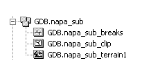
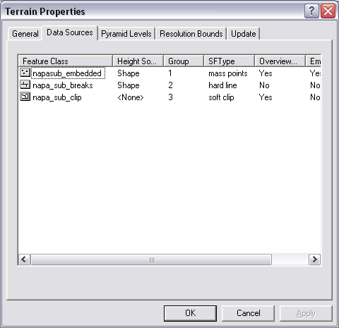
Terrain datasets are surfaces that represent three-dimensional space. They use measurements (stored as feature classes) and rules to generate TIN pyramids to represent elevation. The source feature classes either can be referenced by the terrain dataset or be embedded in the terrain dataset. For an explanation of terrain datasets, read the topics in the book Understanding terrain datasets. You can begin with the topic What is a terrain dataset? You can see two of the feature classes that participate in the terrain—napa_sub_breaks and napa_sub_clip. To find out if there are any embedded feature classes in the terrain dataset, check the terrain properties. Right-click the terrain, and click the Data Sources tab. This will list all feature classes used to create the terrain. In this example a third, embedded feature class—napasub_embedded—was used to create this terrain.
 Top of page
| Field name | Field type | Description |
|---|---|---|
| ID | NUMBER(38) | The unique identifier of the shape pointing to neighbor tiles. NOT NULL |
| TILENR | NUMBER(10) | The composite tile number. This is defined by the terrain's tile system. A value of -1 is reserved for one record containing the centroids of the terrain's perimeter tiles. NOT NULL |
| EMPTYTILE | NUMBER(4) | A value of -1 indicates the tile is void of any measurements. A value of 0 indicates the tile has some data but is incomplete. NOT NULL |
| OTHERTILES | NUMBER(38) (ST_GEOMETRY if using the Spatial Type geometry storage SDO_GEOMETRY if using Oracle spatial geometry storage) | Multipoint shape storing the tile centroid of each surrouding tile that provides measurements to complete the composite tile. |
| Field name | Field type | Description |
|---|---|---|
| ID | NUMBER(38) | The unique identifier for the shape. NOT NULL |
| CLASSID | NUMBER(10) | The class ID of the feature class that's the source of the edits. NOT NULL |
| TILECOUNT | NUMBER(10) | The number of dirty tiles resulting from edits to the feature class. NOT NULL |
| CREATETIME | NUMBER(10) | When dirty tile was created NOT NULL |
| UPDATETIME | NUMBER(10) | When edits occurred NOT NULL |
| DIRTYAREA | NUMBER(38) (ST_GEOMETRY if using the Spatial Type geometry storage SDO_GEOMETRY if using Oracle spatial geometry storage) | Mutlipoint shape containing the tile centroids invalided as a result of edits to the feature class. NOT NULL |
| Field name | Field type | Description |
|---|---|---|
| ID | NUMBER(38) | The unique identifier for the shape NOT NULL |
| TILEROW | NUMBER(10) | The row number of the terrain tile to which the embedded points belong |
| TILECOL | NUMBER(10) | The column number of the terrain tile to which the embedded points belong |
| RESOLUTION | NUMBER(32,8) | Indicates in which pyramid level(s) the points are used Since pyramid levels are cumulative, points participate in levels with resolutions equal to or greater than themselves A special case involves the terrain overview. The resolution of the overview level is indicated with a value of -1. Points assigned this value participate through the entire pyramid. |
| POIINTCOUNT | NUMBER(10) | The number of points in the multipoint NOT NULL |
| NEIGHBORDATA | NUMBER(4) | Indicates whether points are inside the tile neatline boundary; Those outside are used to ensure complete coverage of the tile area. A value of 0 indicates the points are inside the tile. -1 indicates they are outside. NOT NULL |
| SHAPE | NUMBER(38) (ST_GEOMETRY if using the Spatial Type geometry storage SDO_GEOMETRY if using Oracle spatial geometry storage) | Embedded multipoint geometry |
| Field name | Field type | Description |
|---|---|---|
| ID | NUMBER(38) | The unique identifier for the shape NOT NULL |
| ZTOLERANCE | NUMBER(32,8) | The resolution of the pyramid level A value of -1 indicates the overview level. NOT NULL |
| INSIDETILES | NUMBER(38) (ST_GEOMETRY if using the Spatial Type geometry storage SDO_GEOMETRY if using Oracle spatial geometry storage) | Multipoint geometry storing the data tile centroids |
| Field name | Field type | Description |
|---|---|---|
| ID | NUMBER(38) | The unique identifier for the shape NOT NULL |
| TILEROW | NUMBER(10) | The row number of the terrain tile to which the pyramid points/vertices belong |
| TILECOL | NUMBER(10) | The column number of the terrain tile to which the pyramid points/vertices belong |
| RESOLUTION | NUMBER(32,8) | Indicates in which pyramid level(s) the points are used Since pyramid levels are cumulative, points participate in levels with resolutions equal to or greater than themselves. A special case involves the terrain overview. The resolution of the overview level is indicated with a value of -1. Points assigned this value participate through the entire pyramid. |
| POINTCOUNT | NUMBER(10) | The number of points in the multipoint NOT NULL |
| NEIGHBORDATA | NUMBER(4) | Indicates whether points are inside the tile neatline boundary; those outside are used to ensure complete coverage of the tile area. A value of 0 indicates the points are inside the tile. -1 indicates they are outside. NOT NULL |
| SHAPE | NUMBER(38) (ST_GEOMETRY if using the Spatial Type geometry storage SDO_GEOMETRY if using Oracle spatial geometry storage) | Multipoint geometry |
| Field name | Field type | Description |
|---|---|---|
| ID | NUMBER(38) | The ObjectID for the record NOT NULL |
| PROPERTIES | BLOB | Stores the version specific dataset properties |
 Top of page
<DatasetType>esriDTTerrain</DatasetType> <esri:Workspace xmlns:esri="http://www.esri.com/schemas/ArcGIS/9.2" xmlns:xsi="http://www.w3.org/2001/XMLSchema-instance" xmlns:xs="http://www.w3.org/2001/XMLSchema">
<WorkspaceDefinition xsi:type="esri:WorkspaceDefinition">
<WorkspaceType>esriRemoteDatabaseWorkspace</WorkspaceType>
<Version>GDB.WO2557</Version>
<Domains xsi:type="esri:ArrayOfDomain" />
<DatasetDefinitions xsi:type="esri:ArrayOfDataElement">
<DataElement xsi:type="esri:DEFeatureDataset">
<CatalogPath>/V=GDB.WO2557/FD=GDB.napa_sub</CatalogPath>
<Name>GDB.napa_sub</Name>
<Children xsi:type="esri:ArrayOfDataElement">
<DataElement xsi:type="esri:DETerrain">
<Version>2</Version>
<CatalogPath>/V=GDB.WO2557/FD=GDB.napa_sub/TERR=GDB.napa_sub_terrain1</CatalogPath>
<Name>GDB.napa_sub_terrain1</Name>
<DatasetType>esriDTTerrain</DatasetType>
<DSID>2</DSID>
<FeatureDatasetName>GDB.napa_sub</FeatureDatasetName>
<Versioned>false</Versioned>
<CanVersion>false</CanVersion>
<ChildrenExpanded>true</ChildrenExpanded>
<MetadataRetrieved>false</MetadataRetrieved>
<FullPropsRetrieved>true</FullPropsRetrieved>
<PyramidType>0</PyramidType>
<TileSize>6000</TileSize>
<MaxShapeSize>5000</MaxShapeSize>
<MaxOverviewSize>50000</MaxOverviewSize>
<TerrainDataSources xsi:type="esri:ArrayOfTerrainDataSource">
<TerrainDataSource xsi:type="esri:TerrainDataSource">
<Version>1</Version>
<FeatureClassID>875</FeatureClassID>
<FeatureClassName>sde.GDB.DTM_2_DISCONNECT_3</FeatureClassName>
<GroupID>1</GroupID>
<SourceStatus>1</SourceStatus>
<SourceType>1</SourceType>
<SurfaceFeatureType>18</SurfaceFeatureType>
<IsBase>true</IsBase>
<ApplyToOverview>true</ApplyToOverview>
<AutoGeneralize>false</AutoGeneralize>
<ResolutionLowerBound>0</ResolutionLowerBound>
<ResolutionUpperBound>0</ResolutionUpperBound>
<SourceName>napasub_embedded</SourceName>
<HeightField>Shape</HeightField>
<TagValueField />
<ReservedFields xsi:type="esri:ArrayOfString" />
</TerrainDataSource>
<TerrainDataSource xsi:type="esri:TerrainDataSource">
<Version>1</Version>
<FeatureClassID>874</FeatureClassID>
<FeatureClassName>GDB.napa_sub_breaks</FeatureClassName>
<GroupID>2</GroupID>
<SourceStatus>1</SourceStatus>
<SourceType>0</SourceType>
<SurfaceFeatureType>1</SurfaceFeatureType>
<IsBase>true</IsBase>
<ApplyToOverview>false</ApplyToOverview>
<AutoGeneralize>false</AutoGeneralize>
<ResolutionLowerBound>0</ResolutionLowerBound>
<ResolutionUpperBound>2.6</ResolutionUpperBound>
<SourceName />
<HeightField>Shape</HeightField>
<TagValueField />
<ReservedFields xsi:type="esri:ArrayOfString" />
</TerrainDataSource>
<TerrainDataSource xsi:type="esri:TerrainDataSource">
<Version>1</Version>
<FeatureClassID>873</FeatureClassID>
<FeatureClassName>GDB.napa_sub_clip</FeatureClassName>
<GroupID>3</GroupID>
<SourceStatus>1</SourceStatus>
<SourceType>0</SourceType>
<SurfaceFeatureType>10</SurfaceFeatureType>
<IsBase>false</IsBase>
<ApplyToOverview>true</ApplyToOverview>
<AutoGeneralize>false</AutoGeneralize>
<ResolutionLowerBound>0</ResolutionLowerBound>
<ResolutionUpperBound>31</ResolutionUpperBound>
<SourceName />
<HeightField />
<TagValueField />
<ReservedFields xsi:type="esri:ArrayOfString" />
</TerrainDataSource>
</TerrainDataSources>
<TerrainPyramidLevelZTols xsi:type="esri:ArrayOfTerrainPyramidLevelZTol">
<TerrainPyramidLevelZTol xsi:type="esri:TerrainPyramidLevelZTol">
<Version>1</Version>
<PyramidLevelStatus>1</PyramidLevelStatus>
<PointCount>-1</PointCount>
<MaxScale>10000</MaxScale>
<Resolution>5</Resolution>
</TerrainPyramidLevelZTol>
<TerrainPyramidLevelZTol xsi:type="esri:TerrainPyramidLevelZTol">
<Version>1</Version>
<PyramidLevelStatus>1</PyramidLevelStatus>
<PointCount>-1</PointCount>
<MaxScale>20000</MaxScale>
<Resolution>10</Resolution>
</TerrainPyramidLevelZTol>
</TerrainPyramidLevelZTols>
</DataElement>
<DataElement xsi:type="esri:DEFeatureClass">