Generating and updating schematic diagrams


Generating and updating schematic diagrams |
|
| Release 9.3 |


|
ArcGIS Server Schematics supports generating and updating diagrams. To generate/update schematic diagrams using ArcGIS Server, you must publish geoprocessing models that include standard Schematics geoprocessing tools and perform diagram generation/update using the geoprocessing service. The following paragraphs explain how this process works.
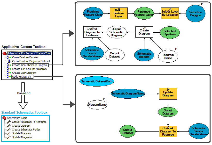
To generate/update schematic diagrams using ArcGIS Server, you must publish geoprocessing models that include Schematics geoprocessing tools and perform diagram generation/update using the geoprocessing service. These models are mainly based on the Create Diagram or Update Diagram GP tool chained with the Convert Diagram To Features GP tool that allows newly generated/updated schematic diagrams to be converted into Feature Diagrams before being consumed by ArcGIS Server.
Figure 1 shows an example of a custom toolbox with models that use the generate/update diagram geoprocessing operations before it is published to be used as a geoprocessing service within ArcGIS Server.

In this sample, the Create GeoSchematic Diagram model chains four standard GP tools:
The Update Diagram sample model chains two Schematics standard GP tools:
Once these models are tested locally, the toolbox containing the models can be published. Only toolboxes, not individual tools, can be published to ArcGIS Server. Each tool in the toolbox becomes a GP task in the resulting geoprocessing service and can then be used by a number of different client applications, including Web Mapping Applications, ArcGIS Explorer, and ArcGIS Desktop.
After publishing such a geoprocessing toolbox resource, all the geoprocessing models are available through geoprocessing tasks. The Web ADF provides a task framework to create, integrate, and distribute Web tasks. With the geoprocessing tasks, you can make use of services that run Schematics geoprocessing generation/update diagram jobs on the server and send the results back to the client application. To learn more about developing applications using tasks, see the Working with tasks topic in the Developer Help. The newly generated/updated diagrams can then be displayed within ArcGIS Server using a map service published from a map document built as explained in the Displaying schematic diagram topic.
The following figure sums up the way of working to generate/update diagrams within ArcGIS Server Schematics that has just been detailled in the previous paragraphs.
