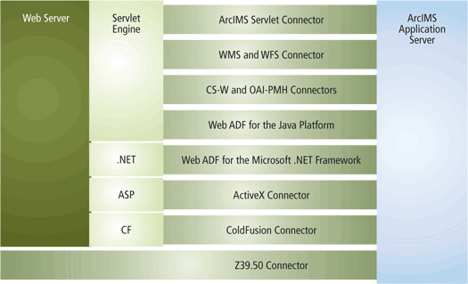
ArcIMS supports several development environments and can process requests from some common standards-based protocols. Since ArcIMS uses ArcXML for communication between the ArcIMS Application Server and Spatial Servers, a mechanism is needed to translate requests from these development environments and standards-based protocols into ArcXML. This translation is done through Application Server connectors and Web Application Development Frameworks (Web ADF). The connectors and Web ADFs reside between the Web server and ArcIMS Application Server.

ArcIMS Application Server connectors
- ArcIMS Servlet Connector. The ArcIMS Servlet Connector is the default connector for ArcIMS. This connector uses the servlet engine to provide a communication link between the Web server and the ArcIMS Application Server. This connector acts as a pass-through for ArcXML generated by the client application. This connector is used by the HTML Viewer, Java Standard and Custom Viewers, ArcExplorer - Java Edition, ArcMap, and ArcPad.
- ArcIMS ColdFusion Connector . The ColdFusion Connector includes a group of tags that process requests from the ColdFusion Server before handing the request to the ArcIMS Application Server. Developers can incorporate ArcIMS maps into ColdFusion applications. This connector is available on Windows and Solaris.
- ArcIMS ActiveX Connector. The ActiveX Connector is a Component Object Model (COM) DLL that can be used in a COM application such as Microsoft ASP. The ActiveX Connector includes an object model for handling typical map and query operations. This connector is available on Windows only.
Web Application Development Frameworks (Web ADF)
The Web ADF supports building Web applications and Web services that can access multiple GIS servers:
- ArcIMS
- ArcGIS Server
- ArcWeb Services
- WMS Map Services
The Web ADF allows you to use the same Web controls and templates to build applications that interact with GIS services from any of these sources. For example, you can combine a map service running on an ArcIMS Server with one running on an ArcGIS Server. This multi-source architecture allows you to transparently overlay map services; map services appear as group layers in a Web application.
The Web ADF includes full integration into a developer environment, Web controls, and an object model that wraps ArcXML.
The Web ADF is available in two environments:
- Web ADF for the Microsoft .NET Framework. The Web ADF for the Microsoft .NET Framework integrates with Visual Studio. Communication with ArcIMS services is provided by the ArcIMS object model. This environment is available on Windows platforms only.
- Web ADF for the Java Platform. The Web ADF for the Java Platform includes Java Server Faces (JSF) based web controls. Communication with ArcIMS services is provided by the Java Connector. This environment is available on all platforms.
For more information about the Web ADF, see the introductory sections of the Web ADF Developer Help. On Windows, this help is accessible from Start | ArcGIS | Developer Help. On UNIX and Linux, run the start_arcgis_help script from the documentation directory.
The Web ADF is available in a separate install from core ArcIMS.
OGC and standards-based connectors
ArcIMS includes connectors so that requests can be made in OGC-compliant formats. The following connectors are available:
- Web Map Server (WMS) Connector . The WMS Connector is a Java Web Application that provides an Open GIS Consortium (OGC)-standard Web Map Service (WMS) interface to data served by ArcIMS Image and ArcMap Image Services.
- Web Feature Server (WFS) Connector. The WFS Connector allows you to publish feature-level geospatial data to the Web. GML (XML vocabulary for the GIS domain) is used to communicate feature and attribute information to clients. A WFS-enabled client can use this streamed GML as a data source to render a map.
- CS-W Connector. The CS-W Connector provides and OGC Standard Catalog Service (CAT 2.0) interface to ArcIMS Metadata Services.
Additional stanadards-based connectors are available to support communication with ArcIMS Metadata Services. These are:
- Z39.50 Connector. The Z39.50 Connector provides and ANSI Z39.50-1995/GEO Profile Standard interface to Metadata Services.
- OAI-PMH Conmector. The OAI-PMH Connector allows another catalog to harvest the contents of a Metadata Service using Open Archives Initiative (OAI) - Protocol for Metadata Harvesting (PMH) requests.
For more information on the connectors used with Metadata Services, see the Metadata Service Help.
The OGC and standards-based connectors are available on all platforms.
