About Coordinate Systems
A coordinate system is a fixed reference framework superimposed onto the surface of an area to designate the location of features within it. The positions of objects on the earth's spherical surface are measured in geographic coordinates. While latitude and longitude can locate exact positions on the surface of the earth, they are not uniform units of measure; only along the equator does the distance represented by one degree of longitude approximate the distance represented by one degree of latitude. To overcome measurement difficulties, data is often transformed from three-dimensional geographic coordinates to two-dimensional projected coordinates.
Learn more about Map Projections
Coordinate systems (either geographic or projected) provide a framework for defining real-world locations. In ArcGIS Explorer, the coordinate system is used as the method to automatically integrate the geographic locations from different datasets into a common coordinate framework for display and analysis.
To work with coordinate systems in ArcGIS Explorer
ArcGIS Explorer provides two property sheets that allow you to work with coordinate systems and geographic transformations, one for 2D Coordinate Systems and the other for 3D Coordinate Systems.
In the 2D Coordinate System property sheet you can choose the coordinate system as well as the geographic transformation(s) to use when projecting layers to the map coordinate system when your map is in 2D Display mode. In the 3D Coordinate System property sheet you can select the geographic transformation(s) to use when projecting layers to the map coordinate system when your map is in 3D Display mode.
To display the Coordinate System properties
- Click the ArcGIS Explorer Button
 .
.
- Click Map Properties.
- Choose 3D Coordinate System or 2D Coordinate System.
3D Coordinate System
Use the 3D Coordinate System of the Map Properties dialog to specify a geographic transformation for each layer on the map. This will ensure that the layers will be projected to the map's coordinate system when you display the map in 3D Display mode.
Learn more about geographic transformations and how to choose the right one in this web-based technical article from Esri Support
In most cases involving the North American Continent you'll see a list of transformations in the Transformation dropdown list that look quite similar. If you are unfamiliar with these transformations or the data, use these guidelines to dertermine which NAD_1983_To_WGS_1984 transformation to use:
- NAD_1983_To_WGS_1984_1 - for the entire North American continent.
- NAD_1983_To_WGS_1984_2 - for the Aleutian islands.
- NAD_1983_To_WGS_1984_3 - for Hawai'i.
- NAD_1983_To_WGS_1984_4 - superseded by NAD_1983_To_WGS_1984_5; the NAD_1983_To_WGS_1984_4 transformation method should no longer be used.
- NAD_1983_To_WGS_1984_5 - for the 48 contiguous United States.
- NAD_1983_To_WGS_1984_6 - for the Canadian province of Quebec.
- NAD_1983_To_WGS_1984_7 - for the Canadian province of Saskatchewan.
- NAD_1983_To_WGS_1984_8 - for the Canadian province of Alberta.
- Learn more about how to determine which NAD_1983_To_WGS_1984 transformation to use in this web-based technical article from Esri Support
2D Coordinate System
Use the the 2D Coordinate System property sheet of the Map Properties dialog to choose the coordinate system to display your map
and also, a geographic transformation for each layer on the map. This will ensure that the layers will be projected to the map's coordinate
system when you display the map in 2D Display mode.
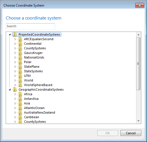
If you don't see the coordinate system you want to use to display your map, select <More...> in the Coordinate System
dropdown list. You'll see a list of Projected Coordinate Systems and Geographic Coordinate Systems:

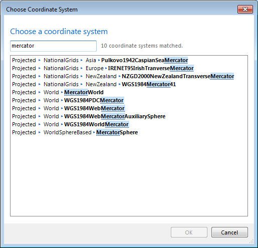
You can type the name or partial name of a coordinate system in the Search box. The dialog box will then display only those coordinate systems
matching the search string.

To determine the coordinate system of a layer
- Right-click the layer in the Contents window and choose Properties... in the layer's context menu.
- In the Layer Properties dialog, click Source Data.
- The Layer Summary section lists the layer's Coordinate System.
Notes
If your layer’s geographic coordinate system differs from the displayed map's geographic coordinate system you may need to use a
transformation to align your data correctly in the map. Where transformations are available they will appear in the dropdown list.
Additional transformations are available in the ArcGIS Explorer Projection Engine Expansion Pack.
Learn more about the basics of projections for GIS professionals in this technical article from Esri Support
 Feedback
 E-mail this topic
 Print this topic
 Feedback
 E-mail this topic
 Print this topic
 .
.
