Adding ArcSDE data expand/collapse all
Related Topics

Adding shapefile data

Adding image data

Adding support for dynamic layers and queries

Adding an extract extension

Adding projection information

Adding SPATIALQUERY

Changing paths to UNC format

expand/collapse item About ArcSDE data

ArcSDE is a high-performance, object-based spatial data access engine. It is implemented in several commercial relational database management systems using open standards and true client/server architecture. ArcSDE makes it possible to store a large number of features in a continuous database. ArcIMS supports ArcSDE raster and vector data.

For raster data, ArcIMS supports the following:

For information on the versions of ArcSDE supported by ArcIMS, see the ArcIMS System Requirements on the ESRI support site.

Using direct connect

You can access ArcSDE using direct connect. You must install the client on each of your Spatial Server machines.

After you install the client, you need to be aware of the following steps specific to ArcIMS:

ArcSDE connection variables

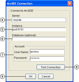
The way you connect to ArcSDE depends on the underlying database you are using. For a detailed description of ArcSDE connection syntax, see ArcSDE connection syntax in the ArcGIS Desktop help.

ArcSDE for Coverages

Coverages store geographic features and their data in a topological vector format that allows for complex geoprocessing and sophisticated spatial analysis. The primary feature types for coverages are nodes, arcs, and polygons. ArcSDE for Coverages is used to access ArcInfo coverages in ArcIMS. Connection variables for ArcSDE for Coverages are the same as for ArcSDE without direct connect.

expand/collapse item How to add ArcSDE data

expand/collapse item Adding an ArcSDE connection

You can add ArcSDE, ArcSDE direct connect, and ArcSDE for Coverages data to your map. If you want to add an ArcSDE Connection but do not have complete information about an ArcSDE instance, contact your ArcSDE administrator.

  1. Click the Add Layers button Add Layers on the Author toolbar to open Catalog.
  2. Under Data Sources, double-click ArcSDE.
  3. Under ArcSDE, double-click Add ArcSDE Connection.

    The ArcSDE Connection dialog box appears.

  4. Type the name of the ArcSDE server to connect to in the Server text box.
  5. Type the instance for your RDBMS in the Instance text box. If using an ArcSDE service, type Port:<port_number>, where <port_number> is the port used for the ArcSDE service. If you are using a direct connection, use the syntax indicated in ArcSDE connection syntax in the ArcGIS Desktop help. If you are using Informix, do not include the odbc_dsn. The direct connect syntax for Informix is sde:informix.
  6. Type the name of a database in the Database text box. For Informix, type the odbc_dsn. For Oracle, leave the field blank.
  7. Type the ArcSDE User name. If you are using OS authentication, type a backslash (\).

    Type in the password. If you are making a direct connection to an Oracle database, the password must be appended with "@<database_service_name>". If connecting with OS authentication, type "password" in the the password field.
  8. Click Test Connection.

    If you see Connection Failed in the message box that appears, click OK and double-check your settings.

    If you see Connection Succeeded in the message box that appears, click OK and continue.

  9. Click OK to connect to your ArcSDE server.


Search code: @author_sde