| Using the Layer Properties dialog | |
| Using the Layer Properties dialog | |
| Related Topics |
|---|
The Layer Properties dialog box is your tool for customizing the appearance of the layers and features of your map. Use it to specify whether a layer is visible within a certain scale range, assign symbology to the features within the layer, or determine the placement of a label in relation to features.
Depending on the type of layer, the Layers Properties dialog box will have 1 or 3 tabs that give you access to the functionality within the dialog. Image layers can only access the General tab while other layer types can also access the Labels and Symbols tabs.
Use the General tab to set the scale dependency of a layer. This involves specifying scale factors above and below which a layer will not display. If you do not want to set scale dependency, or want to remove a previously set scale range, choose Always show layer.
You can also change the layer name that appears in the legend.
Use the Labels tab to set the properties of labels. For point and line layers only, use the Labels tab to specify the placement of labels in relation to features. You can also set a scale range that optimizes when labels will be displayed on your map.
Use the Symbols tab in the Layer Properties dialog box to change the symbol color and style. You can also change the symbol size for point and line layers and the outline color, style, and width for polygon layers.
The Layer Properties dialog can be opened by using any of the following methods:
A. Double-click the layer in the legend.
B. Right-click the layer in the legend and choose Layer Properties. 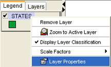
C. Click a layer in the legend to make it active. Click the Layer Properties button  on the Author toolbar to open the Layer Properties dialog box.